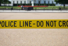
Police unfazed by app feature pinpointing speed traps
Drivers using Google Maps recently may have got some help avoiding police officers on the lookout for speeding drivers.
That’s because of a new feature that allows users to pinpoint the location of speed traps, or spots where police park their vehicles out of sight and try to catch drivers speeding, usually using radar guns.
Introduced across Canada on Apple’s iPhone operating system in October and on Android earlier this year, the feature displays a small radar gun icon at spots on the map where users have reported seeing police speed traps.
Similar features have raised alarm in other jurisdictions over whether they put officers at risk or interfere with police operations, but the response of some police forces in Ontario can be summed up with a shrug.
“While police do not generally encourage the public sharing of information on the location of police traffic enforcement, this is not a new phenomenon,” said Ottawa Police Insp. Michel Marin.
Marin said it’s simply the continuation of a longstanding practice, just by more technologically advanced means.
Drivers have been flashing their lights at oncoming traffic to warn about police cars lying in wait since long before the advent of digital technology, Marin said.
Beyond that, major traffic enforcement operations have been widely reported in newspapers and television newscasts for decades.
“If someone’s running radar sitting at the side of the highway, by the time someone sees that online, the officers probably moved on anyway,” said Ontario Provincial Police spokesperson Bill Dickson. “So that’s not as much of a concern.”
Ontario’s Highway Traffic Act does not specifically address the use of apps or the flashing of lights to alert others to the presence of police, according to Ministry of Transportation spokesperson Kristine Bunker.
However, police can issue tickets to drivers under Section 168 of the act, which forbids them from using high beams within 150 metres of an oncoming vehicle.
Teresa Scassa, a law professor at the University of Ottawa, said police-spotting app features don’t necessarily violate privacy laws either, because users are not giving out personal information about officers, like names or badge numbers.
But Scassa said governments might want to make it an offence to disclose police locations if doing so interferes with effective policing.
The OPP’s main concerns, said Dickson, would be if people used navigation apps to evade RIDE (“Reduce Impaired Driving Everywhere”) programs that target impaired drivers, or if they broadcast the location of ongoing police investigations — neither of which is the stated purpose of the Google Maps feature.
“We can’t say that strong enough, not to share the information in terms of where RIDE programs are or where an ongoing police operation is,” Dickson said. “It could be putting the public’s lives in danger and police lives in danger.”
Waze under fire
Another popular navigation app, Waze, has come under fire in the past for allowing users to report everything from speed traps to traffic cameras to impaired driving checkpoints.
In 2015, Waze drew the ire of the U.S. National Sheriffs Association, which argued the police-spotting function interfered with officers’ ability to catch speeding drivers.
In Winnipeg, the police union said the app put officers’ lives at risk after the municipal government signed a data-sharing agreement with Waze. (The City of Ottawa announced last week a similar partnership that will see it share traffic data with Waze).
Earlier this year, the New York Police Department sent a letter to Google — which bought Waze in 2013 — warning that people who post the locations of impaired driving checkpoints “may be engaging in criminal conduct,” according to a report from The Associated Press. The NYPD letter demanded the company remove the police report function.
The key difference between the Google Maps feature and the equivalent one on Waze — which may explain why the latter has taken more heat than the former — is that Google Maps displays the small radar icon only, indicating a speed trap. A similar feature displays a camera icon to indicate a traffic camera.
Alternatively, Waze’s police-spotting feature displays a mustachioed cartoon police officer, signifying a police presence, but it doesn’t specify what kind other than than “visible” or “hidden.” Users see the police icon, but it’s not immediately clear whether police are there for a speed trap, a sobriety check or lunch break.
A spokesperson for Google Canada said safety is a top priority when developing navigation features.
“We believe that informing drivers about upcoming speed traps allows them to be more careful and make safer decisions when they’re on the road,” said Alexandra Klein.
Drive with care
Joe Coutu, a spokesperson for the Ontario Association of Chiefs of Police, agreed that navigation apps can lead to safer roads — when they’re used properly.
Coutu said drivers who are aware that police are conducting traffic enforcement might change their behaviour by driving slower and following the rules of the road.
“What we don’t want it to do is to become the sort of game where you’re trying to avoid police or get around enforcement,” Coutu said.
Dickson, the OPP spokesperson, said police-spotting app features are likely to stick around because they’re protected by freedom of expression rights.
“We again just ask people to think twice before sharing that kind of information,” he said. “You could be helping to save a life by making sure that someone who’s going through a RIDE program, and is impaired, is stopped and dealt with.”
CBC


Redes Sociais - Comentários