The Kilimanjaro
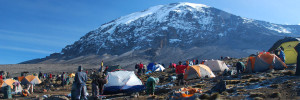
Mount Kilimanjaro, its three volcanic cones, “Kibo”, “Mawenzi”, and “Shira”, is a dormant volcano in Tanzania. It is the highest mountain in Africa, and rises approximately 4,900 metres (16,100 ft) from its base to 5,895 metres (19,341 ft) above sea level. The first persons known to have reached the summit of the mountain were Hans Meyer and Ludwig Purtscheller in 1889. The mountain is part of the Kilimanjaro National Park and is a major climbing destination. The mountain has been the subject of many scientific studies because of its shrinking glaciers and disappearing ice fields.
Kilimanjaro is the highest dormant volcano in Africa.
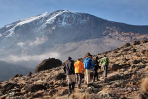 Kilimanjaro is a large stratovolcano and is composed of three distinct volcanic cones: Kibo, the highest; Mawenzi at 5,149 metres (16,893 ft); and Shira, the shortest at 4,005 metres (13,140 ft). Mawenzi and Shira are extinct, while Kibo is dormant and could erupt again.
Uhuru Peak is the highest summit on Kibo’s crater rim. The Tanzania National Parks Authority, a Tanzanian governmental agency, and the United Nations Educational, Scientific and Cultural Organization list the height of Uhuru Peak as 5,895 m (19,341 ft). That height is based on a British Ordnance Survey in 1952. Since then, the height has been measured as 5,892 metres (19,331 ft) in 1999, 5,891 metres (19,327 ft) in 2008, and 5,888 metres (19,318 ft) in 2014.
Geology
The interior of the volcanic edifice is poorly known, given the lack of large scale erosion that could have exposed the interiors of the volcano.
Eruptive activity at the Shira centre commenced about 2.5 million years ago, with the last important phase occurring about 1.9 million years ago, just before the northern part of the edifice collapsed. Shira is topped by a broad plateau at 3,800 metres (12,500 ft), which may be a filled caldera. The remnant caldera rim has been degraded deeply by erosion. Before the caldera formed and erosion began, Shira might have been between 4,900 m (16,000 ft) and 5,200 m (17,000 ft) high. It is mostly composed of basic lavas with some pyroclastics. The formation of the caldera was accompanied by lava emanating from ring fractures, but there was no large scale explosive activity. Two cones formed subsequently, the phonolitic one at the northwest end of the ridge and the doleritic “Platzkegel” in the caldera centre.
Both Mawenzi and Kibo began erupting about 1 million years ago. They are separated by the “Saddle Plateau” at 4,400 metres (14,400 ft) elevation.
The youngest dated rocks at Mawenzi are about 448,000 years old. Mawenzi forms a horseshoe shaped ridge with pinnacles and ridges opening to the northeast which has a tower like shape resulting from deep erosion and a mafic dyke swarm. Several large cirques cut into the ring, the largest of these sits on top of the Great Barranco gorge. Also notable are the Ost and West Barrancos on the northeastern side of the mountain. Most of the eastern side of the mountain has been removed by erosion. Mawenzi has a subsidiary peak named Neumann Tower (4,425 metres (14,518 ft)).
Kibo is the largest cone and is more than 15 miles (24 km) wide at the “Saddle Plateau” altitude. The last activity here has been dated to between 150,000 and 200,000 years ago and created the current Kibo summit crater. Kibo still has gas-emitting fumaroles in the crater. Kibo is capped by an almost symmetrical cone with escarpments rising 180 metres (590 ft) to 200 metres (660 ft) on the south side. These escarpments define a 2.5-kilometre-wide (1.6 mi) caldera caused by the collapse of the summit. Within this caldera is the Inner Cone and within the crater of the Inner Cone is the Reusch Crater, which the Tanganyika government in 1954 named after Gustav Otto Richard Reusch upon his climbing the mountain for the 25th time (out of 65 attempts during his lifetime). The Ash Pit, 350 metres (1,150 ft) deep, lies within the Reusch Crater. About 100,000 years ago, part of Kibo’s crater rim collapsed, creating the area known as the Western Breach and the Great Barranco.
An almost continuous layer of lavas buries most older geological features, with the exception of exposed strata within the Great West Notch and the Kibo Barranco. The former exposes intrusions of syenite.[13] Kibo has five main lava formations:
- Phonotephrites and tephriphonolites of the “Lava Tower group”, on a dyke cropping out at 4,600 metres (15,100 ft), 482,000 years ago
- Tephriphonolite to phonolite lavas “characterized by rhomb mega-phenocrysts of sodic feldspars” of the “Rhomb Porphyry group”, 460,000–360,000 years ago
- aphyric phonolite lavas, “commonly underlain by basal obsidian horizons”, of the “Lent group”, 359,000–337,000 years ago
- porphyritic tephriphonolite to phonolite lavas of the “Caldera rim group”, 274,000–170,000 years ago
- phonolite lava flows with aegirine phenocrysts, of the “Inner Crater group”, which represents the last volcanic activity on Kibo
Kibo has more than 250 parasitic cones on its northwest and southeast flanks that were formed between 150,000 and 200,000 years ago and erupted picrobasalts, trachybasalts, ankaramites, and basanites. They reach as far as Lake Chala and Taveta in the southeast and the Lengurumani Plain in the northwest. Most of these cones are well preserved, with the exception of the Saddle Plateau cones that were heavily affected by glacial action. Despite their mostly small size, lava from the cones has obscured large portions of the mountain. The Saddle Plateau cones are mostly cinder cones with terminal effusion of lava, while the Upper Rombo Zone cones mostly generated lava flows. All Saddle Plateau cones predate the last glaciation.
According to reports gathered in the 19th century from the Maasai, Lake Chala on Kibo’s eastern flank was the site of a village that was destroyed by an eruption.
The origin of the name “Kilimanjaro” is not precisely known, but a number of theories exist. European explorers had adopted the name by 1860 and reported that “Kilimanjaro” was the mountain’s Kiswahili name. The 1907 edition of The Nuttall Encyclopædia also records the name of the mountain as “Kilima-Njaro”.
Johann Ludwig Krapf wrote in 1860 that Swahilis along the coast called the mountain “Kilimanjaro”. Although he did not support his claim, he claimed that “Kilimanjaro” meant either “mountain of greatness” or “mountain of caravans”. Under the latter meaning, “Kilima” meant “mountain” and “Jaro” possibly meant “caravans”.
Jim Thompson claimed in 1885, although he also did not support his claim, that the term Kilima-Njaro “has generally been understood to mean” the Mountain (Kilima) of Greatness (Njaro). “Though not improbably it may mean” the “White” mountain.
“Njaro” is an ancient Kiswahili word for “shining”. Similarly, Krapf wrote that a chief of the Wakamba people, whom he visited in 1849, “had been to Jagga and had seen the Kima jaJeu, mountain of whiteness, the name given by the Wakamba to Kilimanjaro….” More correctly in the Kikamba language, this would be Kiima Kyeu, and this possible derivation has been popular with several investigators.
Others have assumed that “Kilima” is Kiswahili for “mountain”. The problem with this assumption is that “Kilima” actually means “hill” and is, therefore, the diminutive of “Mlima”, the proper Kiswahili word for mountain. However, “[i]t is … possible … that an early European visitor, whose knowledge of [Kiswahili] was not extensive, changed mlima to kilima by analogy with the two Wachagga names; Kibo and Kimawenzi.”
A different approach is to assume that the “Kileman” part of Kilimanjaro comes from the Kichagga “kileme”, which means “which defeats”, or “kilelema”, which means “which has become difficult or impossible”. The “Jaro” part would “then be derived from njaare, a bird, or, according to other informants, a leopard, or, possibly from jyaro a caravan.” Considering that the name Kilimanjaro has never been current among the Wachagga people, it is possible that the name was derived from Wachagga saying that the mountain was unclimbable, “kilemanjaare” or “kilemajyaro” and porters misinterpreted this as being the name of the mountain.
In the 1880s, the mountain became a part of German East Africa and was called “Kilima-Ndscharo” in German following the Kiswahili name components.
On 6 October 1889, Hans Meyer reached the highest summit on the crater ridge of Kibo. He named it “Kaiser-Wilhelm-Spitze” (“Kaiser Wilhelm peak”). That name apparently was used until Tanzania was formed in 1964, when the summit was renamed “Uhuru Peak”, meaning “Freedom Peak” in Kiswahili.
Climbing history
Nineteenth-century explorers
In August 1861, the Prussian officer Baron Karl Klaus von der Decken accompanied by English geologist R. Thornton made a first attempt to climb Kibo but “got no farther than 8,200 feet (2,500 m) owing to the inclemency of the weather.” In December 1862, von der Decken tried a second time together with Otto Kersten. They reached a height of 14,000 feet (4,300 m).
In August 1871, missionary Charles New became the “first European to reach the equatorial snows” on Kilimanjaro at an elevation of slightly more than 13,000 feet (4,000 m).
In June 1887, the Hungarian Count Sámuel Teleki and Austrian Lieutenant Ludwig von Höhnel made an attempt to climb the mountain. Approaching from the saddle between Mawenzi and Kibo, Höhnel stopped at 4,950 meters (16,240 ft), but Teleki pushed through until he reached the snow at 5,300 meters (17,400 ft).
Later in 1887 during his first attempt to climb Kilimanjaro, the German geology professor Hans Meyer reached the lower edge of the ice cap on Kibo, where he was forced to turn back because he lacked the equipment needed to handle the ice. The following year, Meyer planned another attempt with Oscar Baumann, a cartographer, but the mission was aborted after the pair were held hostage and ransomed during the Abushiri Revolt.
In the autumn of 1888, the American naturalist Dr. Abbott and the German explorer Otto Ehrenfried Ehlers approached the summit from the northwest. While Abbott turned back earlier, Ehlers at first claimed to have reached the summit rim but, after severe criticism of that claim, later withdrew it.
In 1889, Meyer returned to Kilimanjaro with the Austrian mountaineer Ludwig Purtscheller for a third attempt. The success of this attempt was based on the establishment of several campsites with food supplies so that multiple attempts at the top could be made without having to descend too far. Meyer and Purtscheller pushed to near the crater rim on October 3 but turned around exhausted from hacking footsteps in the icy slope. Three days later, on Purtscheller’s fortieth birthday, they reached the highest summit on the southern rim of the crater. They were the first to confirm that Kibo has a crater. After descending to the saddle between Kibo and Mawenzi, Meyer and Purtscheller attempted to climb the more technically challenging Mawenzi but could reach only the top of Klute Peak, a subsidiary peak, before retreating due to illness. On October 18, they reascended Kibo to enter and study the crater, cresting the rim at Hans Meyers Notch. In total, Meyer and Purtscheller spent 16 days above 15,000 feet (4,600 m) during their expedition. They were accompanied in their high camps by Mwini Amani of Pangani, who cooked and supplied the sites with water and firewood.
The first ascent of the highest summit of Mawenzi was made on 29 July 1912, by the German climbers Edward Oehler and Fritz Klute, who christened it Hans Meyer Peak. Oehler and Klute went on to make the third-ever ascent of Kibo, via the Drygalski Glacier, and descended via the Western Breach.
In 1989, the organizing committee of the 100-year celebration of the first ascent decided to award posthumous certificates to the African porter-guides who had accompanied Meyer and Purtscheller. One person in pictures or documents of the 1889 expedition was thought to match a living inhabitant of Marangu, Yohani Kinyala Lauwo. Lauwo did not know his own age. Nor did he remember Meyer or Purtscheller, but he remembered joining a Kilimanjaro expedition involving a Dutch doctor who lived near the mountain and that he did not get to wear shoes during the climb. Lauwo claimed that he had climbed the mountain three times before the beginning of World War I. The committee concluded that he had been a member of Meyer’s team and therefore must have been born around 1871. Lauwo died on 10 May 1996, 107 years after the first ascent, but now is sometimes even suggested as co-first-ascendant of Kilimanjaro.
Fastest ascent and descent
The fastest ascent-descent has been recorded by the Swiss-Ecuadorian mountain guide Karl Egloff (born 16 March 1981 in Quito), who ran to the top and back in 6 hours and 42 minutes on 13 August 2014. Previous records were held by Spanish mountain runner Kílian Jornet (7 hours, 14 minutes on 29 September 2010) and by Tanzanian guide Simon Mtuy (9 hours, 21 minutes on 22 February 2006).


Redes Sociais - Comentários